COURSE DESCRIPTION
This course is a thematic study of human activity (population, religion, language, migration, industry) and the global distribution of these activities. The Geosciences Department at SLCC has listed the following as its desired outcomes for students upon the completion of GEOG 1400:
This course is a thematic study of human activity (population, religion, language, migration, industry) and the global distribution of these activities. The Geosciences Department at SLCC has listed the following as its desired outcomes for students upon the completion of GEOG 1400:
- Topics covered will include: global population, migration, folk and popular culture, language, religion, ethnicity, political geography, development, agriculture, industry, urban patterns, and the environment.
- Analyze and determine the spatial distribution, patterns, interrelationships, and ramifications of the concepts covered in class, the textbook, videos, and/or supplemental readings.
- Demonstrate how to think spatially using methods of geographic thought.
- Develop a “sense of place” and connection with the world to become educated global citizens.
- Determine the role humans play in influencing the physical environment and how the physical environment impacts humanity.
- Analyze concepts presented in class using geographic tools and technology (i.e. maps, aerial photography, satellite imagery, etc.).
|
My ArcGIS Map
http://arcg.is/1P16w1F 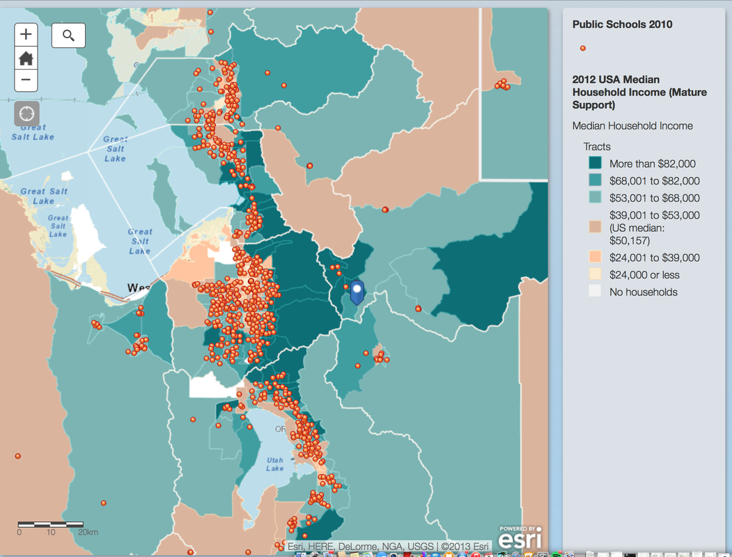
ArcGis Contributing to my Future I am a Health and Exercise Promotion major which means I am extremely invested in the overall health of our planet and the health of our growing society. A huge part of my major is to promote good health and show people how to achieve it, and this mapping tool could also contribute to the future of my career by showing me the areas where my assistance is most needed. AcrGIS mapping has many layers that allow to to see certain things in a specific area. Applying this towards my future career can and will be extremely helpful. These mapping tools can help us see the areas where there are high rates of obesity, starvation, and food suppliers, This would allow me to see where we are lacking healthy food locations and or see the areas that have too many fast food (unhealthy food) options and relate that back to the climbing or lessening obesity rate in that area. |
Map Description & Analysis
Not only has Human Geography taught me about the world and the people who live in it, but it has also given me the knowledge and tools to create my own ArcGIS Map. These online maps can show many filters of the world, including fault lines, household incomes, public transportation routes, and much more. From this class I was able to create my own Map, with layers of my choice, as well as selecting my preferred location. The map I chose to create shows the range of household incomes in my neighborhood and the public education that is valuable within my city. I also chose my base map on a street view so I could see exactly where there schools were located. By using these layers; household income, and public education; I was able to look at the ranges of income around the areas where public education was present. Through this I was able to determine where the highest household income was in relation to the public school zones helping me see if wealthier family tended to live closer or further away from these institutions. This map also can help me see where the lowest rates of household income are located, and the distance they are from the public school institutions. Park City, Utah has a high average household income, therefor most of the areas around the public school zones appear to have high household incomes, but once you looked closer there is a large amount of low household income condensed around the school zones. The areas where this low income is present is also surrounded by large household incomes, averaging the area out to high household incomes around the Public Education Institutions. Park city has very few public schools, due to this the area in which the middle school and high school are located in, which is the heart of park city with some of the most expensive living and the most economic growth, most of the people living in this surrounding area have very high incomes making it hard to see on the map where the low household income is present. My map was only a small creation of layers on one specific location, ArcGIS online maps have many other layers and uses that can contribute to finding information on specific areas around the world. |
